Property Record
1076 Airport Rd, Tappahannock, VA 22560
This Property Is For Sale
Current Lease Availabilities
NEARBY LISTINGS FOR SALE OR LEASE
Property Detail
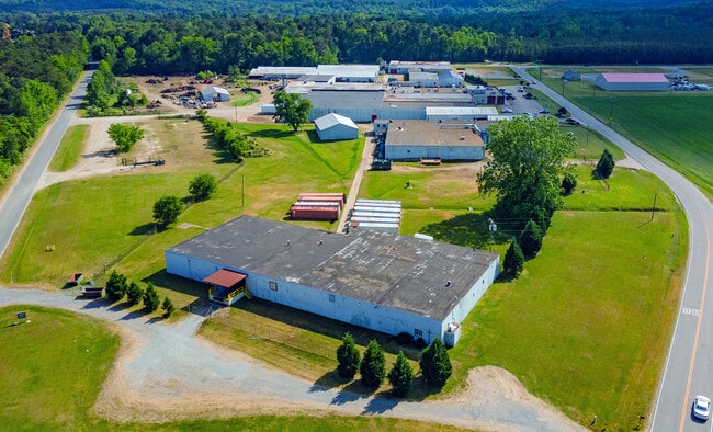
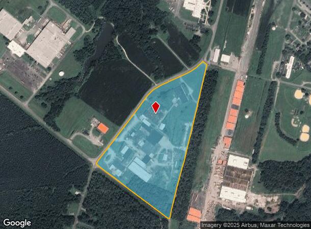
1076 Airport Rd
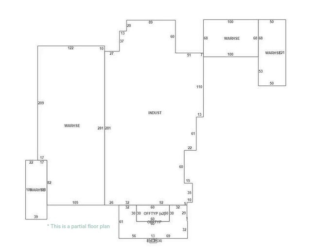
Lightindustrial
PT FLIGHT STRIP
X
Essex
51057C0145F
Virginia
2025
24.75 AC
2025
Virginia Regional
950700
Other Market Areas
52,238 SF
31-50A
DEMOGRAPHICS near 1076 Airport Rd
1 Mile
3 Mile
5 Mile
2024 Total Population
998
3,334
5,407
2029 Population
962
3,284
5,370
Pop Growth 2024-2029
(3.61%)
(1.50%)
(0.68%)
Average Age
41
44
44
2024 Total Households
396
1,456
2,345
HH Growth 2024-2029
(3.79%)
(1.30%)
(0.68%)
Median Household Inc
$38,845
$41,482
$43,796
Avg Household Size
2.40
2.20
2.30
2024 Avg HH Vehicles
2.00
2.00
2.00
Median Home Value
$160,416
$236,021
$248,328
Median Year Built
1978
1984
1982
Nearby Places
- Restaurants
- Banks
- Shops
- Fitness
- Groceries
Nearby Properties
Address
Land Use
TOTAL SIZE
Lot Size
Zoning
Address
Land Use
TOTAL SIZE
Lot Size
Zoning
48,072 SF
51.80 AC
R2
Address
Land Use
TOTAL SIZE
Lot Size
Zoning
40,676 SF
31.24 AC
R-3
Address
Land Use
TOTAL SIZE
Lot Size
Zoning
49,761 SF
14.37 AC
CC1
Address
Land Use
TOTAL SIZE
Lot Size
Zoning
150,844 SF
5.84 AC
CG2
Address
Land Use
TOTAL SIZE
Lot Size
Zoning
8,192 SF
5.98 AC
R3
Address
Land Use
TOTAL SIZE
Lot Size
Zoning
92,427 SF
7.80 AC
R2
Address
Land Use
TOTAL SIZE
Lot Size
Zoning
111,120 SF
10.74 AC
CG2
Address
Land Use
TOTAL SIZE
Lot Size
Zoning
56,908 SF
1.94 AC
CG2
Address
Land Use
TOTAL SIZE
Lot Size
Zoning
7,800 SF
39.80 AC
I1
Address
Land Use
TOTAL SIZE
Lot Size
Zoning
36,090 SF
10.20 AC
CG2
Address
Land Use
TOTAL SIZE
Lot Size
Zoning
91,349 SF
10.56 AC
CG2
Address
Land Use
TOTAL SIZE
Lot Size
Zoning
74,260 SF
7.79 AC
CG2
Address
Land Use
TOTAL SIZE
Lot Size
Zoning
242,044 SF
55.79 AC
M-1
Address
Land Use
TOTAL SIZE
Lot Size
Zoning
40,070 SF
1.30 AC
CG2
Address
Land Use
TOTAL SIZE
Lot Size
Zoning
2,834 SF
2,765 AC
A-1
Address
Land Use
TOTAL SIZE
Lot Size
Zoning
18,673 SF
20 AC
Address
Land Use
TOTAL SIZE
Lot Size
Zoning
837 SF
47.20 AC
I1
Address
Land Use
TOTAL SIZE
Lot Size
Zoning
15,786 SF
17.56 AC
CG2
Address
Land Use
TOTAL SIZE
Lot Size
Zoning
11,473 SF
0.49 AC
CG2
Address
Land Use
TOTAL SIZE
Lot Size
Zoning
17,376 SF
8 AC
R4
Address
Land Use
TOTAL SIZE
Lot Size
Zoning
19.80 AC
A-2
Address
Land Use
TOTAL SIZE
Lot Size
Zoning
52,238 SF
24.75 AC
M-1
Address
Land Use
TOTAL SIZE
Lot Size
Zoning
1,282.09 AC
A-1
Address
Land Use
TOTAL SIZE
Lot Size
Zoning
157,098 SF
92.58 AC
I1
Address
Land Use
TOTAL SIZE
Lot Size
Zoning
7,440 SF
2.42 AC
R1
Address
Land Use
TOTAL SIZE
Lot Size
Zoning
35,591 SF
6.69 AC
M-1
Address
Land Use
TOTAL SIZE
Lot Size
Zoning
16,960 SF
1.60 AC
B-1
Address
Land Use
TOTAL SIZE
Lot Size
Zoning
9,919 SF
4.90 AC
R-3
Address
Land Use
TOTAL SIZE
Lot Size
Zoning
5,588 SF
0.96 AC
CG2
The World's #1 Commercial Real Estate Marketplace
Connect with us
© 2025 CoStar Group
The information above has been obtained from sources believed reliable. While we do not doubt its accuracy we have not verified it and make no guarantee, warranty or representation about it. It is your responsibility to independently confirm its accuracy and completeness. Any projections, opinions, assumptions, or estimates used are for example only and do not represent the current or future performance of the property. The value of this transaction to you depends on tax and other factors which should be evaluated by your tax, financial, and legal advisors. You and your advisors should conduct a careful, independent investigation of the property to determine to your satisfaction the suitability of the property for your needs.